Showing posts with label Sangre de Cristo. Show all posts

Sunday, October 16, 2011

La Bajada


How do you know a book is fraudulent?

When it purports to give a driver an explanation of all the important geological features visible from a car, and, in the section on I-25 from Albuquerque to Santa Fe, doesn’t mention La Bajada Hill.

The La Bajada escarpment rises some 800' from the Santo Domingo basin. The first road, built by the army in the 1860's, had some 28% grades. When the last territorial governor, William Mills, had a better road built in 1910, it had 23 hairpin turns or switchbacks to make the mile and half climb with a maximum 7.8% grade. Railroads then couldn’t handle more than 3%.

Fraudulent may be too strong a term for a book that does provide some useful information, but La Bajada’s not something you can miss if you’re driving south from Santa Fe. You do wonder if the author ever made the drive.


The city was founded in 1610 by Pedro de Peralta as a safer, perhaps better watered, alternative to the Española valley. It was conceived as a citadel.

To get there from the river you had to scale the walls of White Rock Canyon. To get there from the north you had to climb what we now call Opera Hill from the Tesuque valley. To get there from the east you had to cross the Sangre de Cristo. To get there from the south you had to come up La Bajada from the Galisteo river.

The Atkinson, Topeka and Santa Fe Railroad refused to come. It’s engineers skirted the Sangre de Cristo to find an opening to the south. To pacify the local politicians they built a station at Lamy and left it to them to get their goods uphill.

Route 66 originally climbed the hill, but was the source of great complaint by Fred Harvey’s organization who wanted to give rail passengers local tours on buses. When governor Arthur Thomas Hannett suggested rerouting the road from Santa Rosa to Albuquerque, merchants in Santa Fe protested. He was not re-elected in 1927. In the remaining month of his term the former member of the State Highway Commission had the Santa Rosa cutoff built anyway.


The present La Bajada road was built in 1932 three miles east of the original, and later improved for the interstate system. The old road still exists for fans of Route 66. However, it’s not maintained and requires a different vehicle than mine.

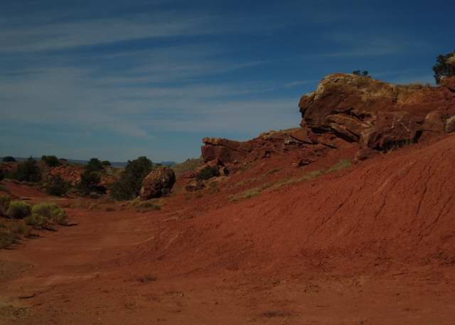
The modern road is still a thrill to drive, at least coming down. You want to look out over the opening vistas of red stone but need to keep the car from accelerating too quickly while others are passing you at much greater speeds.


Going up there’s a third lane and the sheer incline modulates people’s speed. However, because you’re rising through wooded land the ascent seems darker and less exciting than the descent.

Going down, you can’t pull off until you’re at the bottom at the exit to Cochiti Pueblo, which is where these pictures were taken Saturday. They don’t capture the vertigo, but they suggest why I can always tolerate driving to Albuquerque.

Note: For more on the La Bajada road, see David J. Krammer, “Historic and Architectural Resources of Route 66 through New Mexico,” prepared for the National Register of Historic Places in 1993.

Monday, October 10, 2011

Between Dixon and Picuris


Now that I have a new camera I have to test it.

My usual method for day tripping has been to look at the map, find something that looks interesting, load the ice chest, and start driving.

There is nothing that can repeat the absolute surprise you feel when you come upon something like the Abiquiu Dam when you’re not expecting it and nothing you want to do to deaden that heart-stopping awe, that sense of unity with all the explorers from the stone age to the present who’ve been there before.

When I get home, I start to read about the place I’ve just been. Then when I go back, I have some better ideas what to look for and some idea about where it’s safe to pull off the road.

Saturday, I took the new camera back to that road beyond Dixon where I had problems with my tires earlier this summer.

After NM 75 leaves Dixon, it feels very much like a typical mountain road with the Rio Embudo on the right side, an occasional gorge coming down from the left, and continually opening V’s as the road climbs towards the Sangre de Cristo south of the Picuris mountains. The trees are all still juniper, but closer together than they were below.

Then I came to a section where raw rock was exposed, standing on edge. It looked like shale at the Rio Grande end, then layers of sandstone. However, they seemed so weathered they had no distinct colors, and I’m not sure I even know what shale looks like, other than it’s gray.

My first thought was, why on earth did anyone go to the expense of blasting a road through here. This is New Mexico, where they didn’t widen the road to Los Alamos until after I moved here. Route 75 was described as “a graded dirt road” in the 1930's WPA Guide when the road that came up from Chimayó through Truches and Las Trampas could get you to Picurus pueblo and Peñasco.

I spent yesterday learning absolutely nothing.


The Española Basin, which tilts west down to the Rio Grande, ends at Velarde. The San Luis Basin, which tilts east, begins farther north. Between the two lies a diagonal belt of disruption that goes from the Picuris mountains to the northeast through the Embudo Fault across the peninsula between the Chama and Rio Grande rivers toward the opening into Santa Clara Canyon.

I presume I was somewhere on the edge of that fault, but can get no confirmation. Is this what a fault looks like?

Sunday, October 9, 2011

The Journey Begins


I finally talked back to my boss one too many times.

Or, he finally made me mad one too many times.

Take your choice.

Two weeks ago he came in angry about something, maybe the extra zero on an invoice. When he paused, I reminded him it really was time for him to find my replacement.

Besides, I added, now that I get social security, I didn’t want to pay taxes on it.

There’s nothing like a tax scam to motivate the man.

Within days the ad was in the paper, he was looking for the best qualified person he thought he could bully, and I was counting the days to freedom.

Of course, retirement is the great bluff caller.

All those things you’ve been saying you’d do, if only you had time.

Well, now you have time and no excuses.

My boss’s mother came in to see what I was going to do.

I told her that since I'd had to buy a new car in March, I wanted to drive around the state and look at places I hadn’t truly seen.

I reminded her that the Las Conchas fire this summer had gotten me started, those days when the smoke was so bad I climbed into the car and drove towards Taos just to get my lungs into air conditioning.

The first time I headed out I had no map, no plan. I only knew I couldn’t go south or west because of the smoke. I didn’t want to go east because the road to Chimayó is too treacherous. That left Taos.

I can’t say I had no map. When I pulled it out I discovered it was issued when Garrey Carruthers was governor. That was between 1987 and 1991. I moved to New Mexico in the fall of 1991. While I’ve seen little evidence of road construction in the past 20 years, I thought I really could do with something better.

A friend whom I’ll simply call the Rock Queen and I went scavenging in Borders, but it was early days and there were no bargains. However, they did have DeLorme’s atlas for the state, and it’s been worth every penny I overpaid.

The next time the smoke got bad, I took the Dixon cut off. Just as I passed the crest of the Sangre de Cristo and headed towards the Carson National Forest, the car’s warning system came up to tell me I had a tire going soft. Route 75 may be a state road, but it’s about as isolated as you want to get in this state.

The next day one of the tires was flat. The tow truck operator, the car dealer, the tire dealer - none could see any reason why. The only possible explanation is that the manufacturer used soft tires to get better car mileage, and such tires aren’t really good enough for driving on two lane roads in New Mexico where shoulders are rarer than the need to get out of the way of some hell hound riding your bumper.

So the next purchase was a new set of tires.

My next expeditions were still day trips into parts of Rio Arriba county. It soon became apparent that gas stations don’t exist once you leave Española. All many towns have left are convenience stores with slow turn over.

I was grateful that car does get good mileage.

I also learned to always throw ice and bottled water in the cooler and a bag of potato chips, just in case. I wasn’t going to do any better in those out of the way convenience stores, and the local ones were probably cheaper.

Last week, after my boss had narrowed his choice, I ordered a new camera, one so cheap I could replace it if it bounced off the car seat. I picked the Sony that advertised wide-angled landscape capabilities. That was the one thing my current camera didn’t do well, though I will admit expecting it to do close ups of a fire some 20 miles away is a bit much.

Again, I learned inexpensive is another way to provide quality by eliminating necessities. In this case, you have to remove the battery to recharge it. It’s possible to buy some kind of device to connect the charger to the car’s electric system, but it’s really cheaper just to buy more batteries and a surge suppressor for those times I expect to spend in some motel in some remote part of this state.

Photograph: The Las Conchas fire taken from my back porch on the first day just before 8pm when the flames were becoming visible in the smoke. I pushed the close-up focus beyond the capacity of the camera to handle both the foreground and the Los Alamos area some 20 miles away