Tuesday, February 14, 2012
The Ditch - Crossing the Highway
I know as much as I’m going to know about the source of our local acequia until I go to Chimayó to look at the mother dam. It’s time to return to where I last saw the ditch, below the highway and great mound, and start to find out how it gets from there to the far arroyo.
I returned to the parking lot with all the “do not enter” signs and began walking towards the ditch, on the outside of barbed wire.
I couldn’t get very close to the diversion point, but it was obvious as I neared the utility pole where the outlet existed.
I looked across the road at an odd cut in the mound.
When I got across the road, I could see where the water came over. Two culverts on this side of the road, two controls on the other.
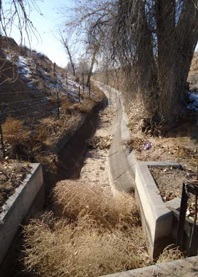
From there the concrete lined ditch began its final journey up the mound.
I still have no idea how the water does that, and it’s the wrong season to go watch. I have to wait spring when the ditches are running to see how water runs uphill.
Photographs:
1. Local acequia below 84/285, 3 February 2012.
2. Gate and fence preventing access to the land with the ditch, 17 January 2012.
3. Ditch controls below 84/285, 3 February 2012.
4. Ditch path above 84/285, 3 February 2012.
5. Water outlets above 84/285, 3 February 2012.
6. Ditch heading up the mound, 5 February 2012.
Subscribe to:
Post Comments (Atom)


No comments:
Post a Comment