Friday, February 10, 2012
The Ditch and the Highway
Design decisions by road engineers are not intuitive. You’d think they’d find the easiest route through terrain that changes level because it would be the cheapest, require fewer technical skills and less heavy equipment. Politics and population density, of course, always override those factors.
The route of 84/285 into Española is a puzzle. According to the area USGS map, the highway is just down from a 5750' gradation line on a great Tertiary mound that immediately rises another 25' on the one side and drops 25' on the other.
Why did they chose that path when it required moving so much dirt, then stabilizing the banks on both sides? In addition, they had to put that dirt somewhere. At least some of it was pushed on down the road toward the Santa Cruz river, because several of the surviving houses along the highway near the river crossing are way below the grade of the road.
There had to be some problem with that lowland alluded to by the use of checkered green squares on the map that made it more difficult to use than cutting through a great pile of unstable rock and sand.
I drove that stretch of road looking for some safe way to see the lower land. Most of the drives in that direction were private and looked steep enough to require a mountain goat to scale in bad weather.
When I did find one, I was totally surprised. About half way down the bank I saw the concrete banks of the local acequia.
Even more surprising, when I looked out over the lowlands I saw the rear addition of Iglesia de la Santa Cruz de la Cañada.
This section of road was just over a mile southwest of the village of Santa Cruz. The red line in the middle ground was the Santa Cruz river because those trailers are on the other side. Here was the river near my feet, not somewhere way north.
I started walking upstream along the ditch and discovered something else. Water from the highway was channeled into it. This means that, in an especially heavy storm, water from 84/285 is dumping into the near and far arroyos, digging those bottoms even deeper.
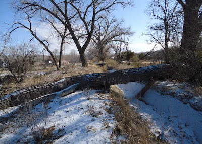
I stopped when I got to someone’s territorial marker, one that may have dropped accidentally, but deliberately hadn’t been cleared.
I looked beyond the tree. The ditch turned toward the river and began to go downhill. Down hill.
When I got home I looked more carefully at a map to see how I could have such a wrong idea about the course of the Santa Cruz river. The men who built the modern road from the Roman Catholic village of Santa Cruz to the Rio Grande made even more puzzling decisions than those made by the state engineers. Route 76 follows the river for a short time, then turns northwest to give the illusion the village is to the north.
It doesn’t meet 84/285 near the commercial area that developed around the Oñate bridge and the railroad, but comes out in what must have been comparatively empty land south of what was once a Mormon settlement at Fairview. Only a car would go there; not a man walking or driving an animal.
Photographs:
1. Road cut on 84/285 coming into Española, 27 January 2012.
2. Local acequia below 84/285, 3 February 2012.
3. Back of Iglesia de la Santa Cruz de la Cañada from the bank below 84/285, 3 February 2012. The line of red crossing the midground is sandbar willow growing along the Santa Cruz river. I drove over; those trailers are on the other side of the river. Santa Cruz badlands are in back.
4. Drainage for water from the highway dumping into the acequia, 3 February 2012.
5. Tree across the local acequia, 3 February 2012.
6. The local acequia turning in the direction of the Santa Cruz river, 3 February 2012; the fallen tree is in the center.
7. Intersection of Santa Cruz Road (route 76) with Riverside Drive (route 68).
Subscribe to:
Post Comments (Atom)


No comments:
Post a Comment