Friday, October 21, 2011

Rat Mazes


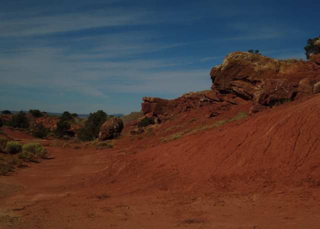
I finally got out to the far arroyo yesterday. I usually walk out on Sundays, but last weekend I thought, I can do that anytime now, I have something else I want to do today.

As I followed ATV paths through the prairie that sits above a ranch road, I realized I didn’t need to just walk where I usually did, I could go farther north and see if I could get to the point where the arroyo crosses the county road.

As I ventured farther, I thought, how much we turn our supposed encounters with wild nature into comfortable routines. Every weekend I go out at the same time, walk the same path. Am I just condemned to protect myself from novel stimuli?


But then I remembered there were things that created my patterns, and only some of them change with retirement. While I tell others the reason I walk is my doctor made some strong noises, the real reason is I want to watch how the plants change from week to week and use photographs as my notes.

I learned plants have many adaptions to the sun in this bright, high altitude environment. One is that as the air warms, the rate of photosynthesis increases. Before the rate goes beyond the limits of a plant’s ability to process the energy, it finds ways to protect itself. One obvious technique is deliberately wilting during the day.

A less obvious method is the alteration of its biochemistry so that flower parts that absorb energy from the sun in the morning begin to reflect it before noon. It’s called the violaxanthin cycle.

You can’t see the difference in reflectivity, but the camera can. It’s thus much easier to photograph a flower before it’s gone into its protective mode. This means, in the summer, I leave early and get home by 9:30.


However, there’s also a lower limit for when I can walk. My camera isn’t able to take decent pictures early in the morning. Pictures are either muddy or look like they came from the bottom of an aquarium. As sun angles change in fall, I can photograph flowers much later in the morning, but I also can’t begin as early.

A second natural factor that has influenced when I walk is the wind, which comes up when the air warms. My camera isn’t quick enough to catch flowers on moving stems. You don’t realize until you try to photograph them, how many plants are in motion when you can’t yet feel a breeze. Such flexibility is, no doubt, another adaption to our hostile environment.

There is a band of time available then, which may be longer now than in July, but is still absolutely determined by nature.


It’s convenient that the natural limits for photographing flowers coincide with some personal ones. My body can’t tolerate high heat and bright sun. There’s a point in the morning when the air changes, when the sun becomes warmer, that forces me indoors.

I suspect my limits are related to some lung problems I developed as a child. I grew up staying out of the sun and walking more slowly than others. There was probably some early feedback cycle that led me to look at the ground to shelter my head, which in turn meant I began to notice plants and stones, which in turn made me go slower to notice more. It can take me 90 minutes to walk a little over a mile here on a Sunday.

It so happens the arroyo has areas where there are many plants, and other areas where there are few. I’ve explored some of those areas, but haven’t gone back to see what’s beyond or to try to figure out why the plants appear where they do. My usual walk, my personal rat maze, limited as it is by natural factors and my physical level of energy, stays within the limits of predictably interesting plants.


Retirement can’t undo the consequences of my parents’ smoking and housekeeping habits.

I don’t think I have the same limits when it comes to exploring the land at a more general level. My car protects me from the heat. I haven’t yet discovered if the sun has any effects on my ability to photograph rocks.

For now, I drive out later in the morning, after the sun has reached that point that sends me indoors. I could leave earlier, but my mind is more creative when I first wake and I don’t want to get into the car until I’ve come to the end of that particular cycle. It’s when I write.


The only other limit I know so far is that I have a limited capacity to be stimulated. If I see something that overwhelms my senses in some way, I might as well return home. I won’t notice any thing more, no matter how spectacular until I’ve fully absorbed what I’ve already seen. It can take hours.

So, I’m venturing out slowly, sometimes looking at those things like La Bajada Hill that I deliberately ignored so I could get on with my life, get to Albuquerque to buy something. In a way, I’m building immunities. Once I’ve fully absorbed my near environment, then I can pass through it quickly to get to something new.


There’s one routine that won’t go away, and may even expand: downloading cameras, recharging batteries, renaming pictures and taking notes on them while I still remember what they are. These tedious, but necessary tasks have become part of my decompression routine, part of the way I process the stimulus from the day, and reset my sensory receptors for the next outing.

If, as I anticipate, I’m going to be spending time in motel rooms in places where the natural landscape is more interesting than the human one, this may become a welcome time hog.

The major difference retirement has made so far is that my adventures no longer need to be limited to the time on weekends that isn’t already committed to such chores as the weekly visit to the post office, but I can't suddenly ignore natural rhythms.


Pictures taken yesterday, from top to bottom are: 1- cottonwoods, 2 - strap-leaf spine aster, 3 - chamisa, 4 - Russian thistle, 5 - juniper berries, 6 - purple aster, 7 - mushrooms, and 8 - tamarix surrounded by chamisa with juniper in the back.

Thursday, October 20, 2011

White Sand


There are things you always say you’re going to do, and something always intervenes.

Every time I drive north towards Taos from Velarde I tell myself I really must pull over on the way back and look. Fallen lava boulders litter the right shoulder as you rise. By necessity, the turn offs are all on the other side. The road has too many blind spots to simply cross over.

But then, when you’re coming home, you’re, well, coming home. It’s a different mental state. There’s never time to pull over.


Well, I finally did it. When I was coming back from the Dixon area a few weeks ago, I pulled over in some of the places between Embudo and Velarde where the rift is narrow, the Rio Grande close to the road.

The look up towards Taos isn’t quite as dramatic as it was when I was driving north - but then it’s like the drive down La Bajada Hill - there are no turn offs when the rocks are the most menacing. The turn offs are only where there’s room, which, by definition, is not where it’s most exciting. Perspective is different from fifty feet across the road.


The river turns out to look like a river there, like any river anywhere in the country where water actually flows and doesn’t simply ripple around sand islands as it does in Española. Nice, unusual actually for New Mexico, but conventional still the same.

Then there’s the unexpected, the thing you didn’t know was there because you never stopped.

In this case, there was a patch of white sand near the river with Russian thistles and purple asters. You think, wait a minute, white sand? New Mexico?


The White Sands in the Tularosa Valley are gypsum dunes. This glittered in the sun. It had to be ground quartz, which of course is as much silica as sand. In fact ground pure quartz provided the material for Venetian glass makers.

Quartz has the greatest weather resistence of any of the rocks in the area. It’s often the last remaining eroded rock from the Sangre de Cristo. This “dune” looks suspiciously like how that sedimentary grey rock I saw earlier in the day beyond Dixon would look if everything soft disappeared and left only the quartz and shining mica. And it photographs the same way, too brown and out of focus, or all glare.

Sunday, October 16, 2011

Geology for Dummies*


* Well, not exactly dummies - but for those of us born into an earlier era, there comes a time when it’s necessary to step back and try to grasp what any modern child might learn today in grade school.

When I was young in glacier dominated Michigan there were simply seven continents, and some rather mysterious drawings of folds, faults and subduction zones. Since nothing really mattered before the Pleistocene, I ignored those drawings.

Since then, scientists have agreed on the existence of plate tectonics and continents are no longer givens, but the results of processes. Here in the Española Valley we’re on the boundaries of plate activity that I’ve spent the past few hours trying, once again, to understand.

The Wikipedia entry on the Wyoming Craton has a useful schematic showing the elements that coalesced or were absorbed into the Laurentian plate that became North America. This part of New Mexico was somewhere on the boundary of the collision of a southeast facing section of that continent with Yavapai-Mazatzal that resulted in lines of weakness that were subsequently buried under layers of sedimentary shale, sandstone and limestone.


Laurentia later overrode the Farallon plate in the Pacific. As the last, western most section of Farallon was swallowed, undissolved bits on the eastern side tipped up as part of the mountain building that produced the Sangre de Cristo.

When the Farallon plate finally did disappear, one section of the North American plate began rotating clockwise to drift into the newly vacated area. As it shifted, the great rift began to open as one part of the land shifted with it and another stayed in place. As the rift expanded, blocks of land roughly defined by those old Yavapai-Mazatzal collision lines dropped, some facing east, some facing west and magma welled through the Jemez Lineament.

The Emdudo faults are the southwest-northeast northern frontier of the Española valley and the La Bajada faults part of the southwest-northeast running southern one. Almost no displacements occur without some tilting. Those visible at the Cochiti exit are mild, those a few miles away at the Garden of the Gods are extreme.

The layers everywhere are probably the same, but what’s visible is probably as much a function of road building as natural forces. At La Bajada the lower red stones are more visible than the lighter colored stones above that either are covered or have washed away. At the Garden of the Gods, the limestone has lasted longer than the softer red sediments.


Above picture from Garden of the Gods on State Road 14; the others from La Bajada at the Cochiti exit.

La Bajada


How do you know a book is fraudulent?

When it purports to give a driver an explanation of all the important geological features visible from a car, and, in the section on I-25 from Albuquerque to Santa Fe, doesn’t mention La Bajada Hill.

The La Bajada escarpment rises some 800' from the Santo Domingo basin. The first road, built by the army in the 1860's, had some 28% grades. When the last territorial governor, William Mills, had a better road built in 1910, it had 23 hairpin turns or switchbacks to make the mile and half climb with a maximum 7.8% grade. Railroads then couldn’t handle more than 3%.

Fraudulent may be too strong a term for a book that does provide some useful information, but La Bajada’s not something you can miss if you’re driving south from Santa Fe. You do wonder if the author ever made the drive.


The city was founded in 1610 by Pedro de Peralta as a safer, perhaps better watered, alternative to the Española valley. It was conceived as a citadel.

To get there from the river you had to scale the walls of White Rock Canyon. To get there from the north you had to climb what we now call Opera Hill from the Tesuque valley. To get there from the east you had to cross the Sangre de Cristo. To get there from the south you had to come up La Bajada from the Galisteo river.

The Atkinson, Topeka and Santa Fe Railroad refused to come. It’s engineers skirted the Sangre de Cristo to find an opening to the south. To pacify the local politicians they built a station at Lamy and left it to them to get their goods uphill.

Route 66 originally climbed the hill, but was the source of great complaint by Fred Harvey’s organization who wanted to give rail passengers local tours on buses. When governor Arthur Thomas Hannett suggested rerouting the road from Santa Rosa to Albuquerque, merchants in Santa Fe protested. He was not re-elected in 1927. In the remaining month of his term the former member of the State Highway Commission had the Santa Rosa cutoff built anyway.


The present La Bajada road was built in 1932 three miles east of the original, and later improved for the interstate system. The old road still exists for fans of Route 66. However, it’s not maintained and requires a different vehicle than mine.

The modern road is still a thrill to drive, at least coming down. You want to look out over the opening vistas of red stone but need to keep the car from accelerating too quickly while others are passing you at much greater speeds.


Going up there’s a third lane and the sheer incline modulates people’s speed. However, because you’re rising through wooded land the ascent seems darker and less exciting than the descent.

Going down, you can’t pull off until you’re at the bottom at the exit to Cochiti Pueblo, which is where these pictures were taken Saturday. They don’t capture the vertigo, but they suggest why I can always tolerate driving to Albuquerque.


Note: For more on the La Bajada road, see David J. Krammer, “Historic and Architectural Resources of Route 66 through New Mexico,” prepared for the National Register of Historic Places in 1993.

Tuesday, October 11, 2011

I Am Not a Camera


The sun’s rising later. It’s dark when I wake at six. Instead of getting up, I check the heated mattress pad is still connected and snuggle back in. It’s the best time for unstructured thinking.

Some people have everything organized. Before they go on a trip, they’ve read the guidebooks, have an itinerary, know what to expect. Perhaps they’re anxious they’ll never get another chance, that this is their one opportunity and they can’t afford to blow it.

I haven’t classed them yet as a separate species, but it’s a possibility.

Or maybe I should be thankful my mother was too intimidated by Spock and Freud to do anything serious about toilet training.

I learned long ago there’s no place in this country I can’t return to. That doesn’t mean things won’t change. Some evenings clouds are so special I wish could remember them. But there’s always the possibility for something wonderful some other night, some other summer.

The freedom of retirement is that time constraints are gone. If I didn’t get quite the picture I wanted Saturday I can drive back today. Or will be able to soon. Please let that woman who interviewed for the job yesterday come to terms with my boss.

A camera matters if you’re not blessed with a painter’s imagination and skills. I may not be able to recall those clouds, but it should remind me.

And so, this morning as I lay in bed I returned to the problem of photographing rocks that apparently send no signals digital equipment can recognize. I thought maybe I should simply take a picture of the same section of that rock with each light setting on the new camera to see the differences.

Maybe tonight.

This morning there was more light coming through the kitchen window and camera settings made do difference. The rock was determined to be brown and out of focus.


I took out the other camera, the close up one, which is turning out to be much more difficult to learn than I expected. It rarely gives me what I want when I first try, but always teases me with possibilities. It makes clear, it’s always my fault it doesn’t do what’s expected.

It folds in half, so it can be set it on its base in a V or triangle to take pictures. However, the lens is at an angle to the flat rock and gets blinded by reflecting light. I tried standing it on its end in a great U so the lens was perpendicular to the rock and things got better.

Then I decided to take a wet paper towel and wash the rock in a few places. As a child I learned it was worth while washing quartz, but useless if not dangerous with sandstone. The idea of washing a sedimentary rock is quite alien.

However, I discovered the wet rock photographed better than the dry one. Perhaps the water plays with the lens so the light reflects differently. It was finally possible to see the bits of mica and the flakes of quartz, though the focus was still fuzzy, the glints bright blurs, and the light glaring.


I have no choice but to master these cameras - a new one won’t be better, just different. But I curse them a lot, because throwing them across the room would, contrary to most rules of punishment, actually hurt them more than me.

Please, I beg them, if you can’t see what I see, can’t you please show me something better?

Tell me, is that pebbly surface of dark carbon and white silica something the land looked like before it hardened into rock? Can you show me the past?

Monday, October 10, 2011

How Hard Can It Be

How hard can it be to photograph a rock?

It’s not a child or an animal. It doesn’t move.

It’s not a plant. It doesn’t defensively reflect light.

How hard can it be?

The answer turns out to be, how hard can it be to photograph something no engineer cares about?

I had picked up a piece of that gray fallen rock on the road to Picuris to take to the Rock Queen to see if she knows if it’s shale or not. It is sedimentary, contains some quartz and mica, and crumbles a bit.

My old trusty camera took reasonable pictures, but not with any great detail. The quartz, or what I assume is quartz, appears as white blurs.


My first attempts with the new camera used default settings which let in too much light. I hadn’t washed the rock, and it picked up the browns. It looks more like sandstone than anything.


After I tried again with different light settings, the color was better but much too dark. In some cases it was possible to get some sense of surface detail, but not much. It looks more like an old piece of bark than a rock.


I tried another camera someone had advertised as good for closeups including rocks. I hadn’t noticed the dead leaf until the camera caught it. Unfortunately, lighting is still a problem. The reflective quartz washes out the surrounding color.


I’m serious. How hard can it be to take a picture of a rock?

You get to an age when it no longer matters if a challenge makes sense, so long as you can meet it.

So, how long will it take me to turn a mute, mutant, mutinous piece of digital equipment into something useful?

Between Dixon and Picuris


Now that I have a new camera I have to test it.

My usual method for day tripping has been to look at the map, find something that looks interesting, load the ice chest, and start driving.

There is nothing that can repeat the absolute surprise you feel when you come upon something like the Abiquiu Dam when you’re not expecting it and nothing you want to do to deaden that heart-stopping awe, that sense of unity with all the explorers from the stone age to the present who’ve been there before.

When I get home, I start to read about the place I’ve just been. Then when I go back, I have some better ideas what to look for and some idea about where it’s safe to pull off the road.

Saturday, I took the new camera back to that road beyond Dixon where I had problems with my tires earlier this summer.

After NM 75 leaves Dixon, it feels very much like a typical mountain road with the Rio Embudo on the right side, an occasional gorge coming down from the left, and continually opening V’s as the road climbs towards the Sangre de Cristo south of the Picuris mountains. The trees are all still juniper, but closer together than they were below.

Then I came to a section where raw rock was exposed, standing on edge. It looked like shale at the Rio Grande end, then layers of sandstone. However, they seemed so weathered they had no distinct colors, and I’m not sure I even know what shale looks like, other than it’s gray.

My first thought was, why on earth did anyone go to the expense of blasting a road through here. This is New Mexico, where they didn’t widen the road to Los Alamos until after I moved here. Route 75 was described as “a graded dirt road” in the 1930's WPA Guide when the road that came up from Chimayó through Truches and Las Trampas could get you to Picurus pueblo and Peñasco.

I spent yesterday learning absolutely nothing.


The Española Basin, which tilts west down to the Rio Grande, ends at Velarde. The San Luis Basin, which tilts east, begins farther north. Between the two lies a diagonal belt of disruption that goes from the Picuris mountains to the northeast through the Embudo Fault across the peninsula between the Chama and Rio Grande rivers toward the opening into Santa Clara Canyon.

I presume I was somewhere on the edge of that fault, but can get no confirmation. Is this what a fault looks like?